
 Highest point
 Lowest point
 Sum of driveways
 Sum of downhill
 High slope sections
 Marking
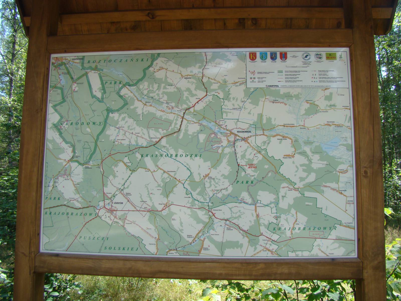
This 45-kilometer-long trail runs through one of the most interesting parts of the Roztocze region. The first part runs through the Roztocze National Park, while the second part runs from the village of Guciów through the Krasnobród Landscape Park. It ends at the edge of the Puszcza Solska Landscape Park. It runs mainly through mixed forests in the first part and through pine forests in the second part, overgrowing sandy, hilly areas of this picturesque corner of the Lublin region.
The general course of the trail is as follows: Zwierzyniec (0.0 km) - Guciów (8.6 km) - Bondyrz (11.4 km) - Hutki (17.5 km) - Krasnobród, St. Roch Shrine (23.4 km) - Krasnobród (25.1 km) - Łuszczacz (32.7 km) - Ciotusza Nowa (38.9 km) - Majdan Sopocki (45.3 km).
The trail starts in the centre of Zwierzyniec. It runs to Krasnobród along the Wieprz River valley, and then, with hills and forest tracks of fairly sandy surface, runs to the locality of Majdan Sopocki. There are many interesting sites and objects along the route, but due to the surface and elevation in the second part (beyond the locality of Krasnobród) it is recommended for experienced cyclists who are in good shape. In its first part, from the locality of Zwierzyniec to the locality of Krasnobród (about 25 km), the route is much easier, and probably more interesting.
The trail is very well-signposted. Only between the villages of Trzepieciny and Bondyrz, in the Wieprz river valley, are there no branching-off signs. The signposting is made in accordance with the standards of the Polish Tourist and Sightseeing Society (PTTK), metal type R-1 and R-3 and painted on trees. The trail is well managed, especially in the first section, between the localities of Zwierzyniec and Krasnobród. Along the way, we encounter numerous rest areas, especially in the Wieprz River valley. In the second, more difficult part of the route, the infrastructure is less well developed, but there are more boards with route maps.
By and large, the trail consists of two sections, completely different in its nature. The first part, running in the Wieprz River Valley from the locality of Zwierzyniec to the village of Hutki, is an easy and rather flat route, devoid of longer ascents and descents. The route runs through the national park to the locality of Guciów and is by far the most attractive in landscape terms. In the village of Guciów you can see a private open-air museum - an ethnographic homestead, which is one of major attractions of this trail, also for children. This part of the route ends in the village of Hutki, at the artificial lake on the Wieprz river, near the locality of Krasnobród.
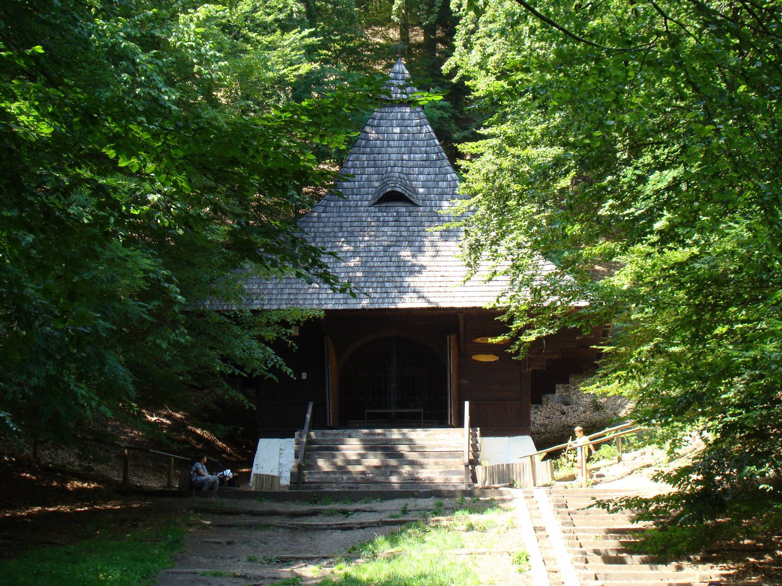
At this point the trail diverts south, climbing the first of the hills that appear in the second part of the route. The difference in altitude is quite significant and the cyclist has to overcome an ascent of about 90 meters over a distance of about 3 km. Fortunately, this section of the route has a fairly good ground surface. Routing the trail over this elevation dominating over the locality Krasnobród has its purpose. After crossing the pass, the route leads through the forest towards the St. Roch shrine, a picturesque religious building, surrounded by numerous legends, in the nature reserve of the same name. This place is a very popular destination for strolls made by tourists and spa-goers, staying in the nearby locality of Krasnobród.
People who want to avoid this significant ascent and descent may give up the ascent in the village of Hutki and go straight to the locality of Krasnobród. This will allow you to see the centre and monuments of this popular resort in the Roztocze Region. The St. Roch Shrine can be reached from the locality of Krasnobród by cycling along Kościuszki street, and after visiting it, continue your journey along the route. You can also make a loop, follow the trail from the village of Hutki to the shrine and return to the locality of Krasnobród, from where you can conveniently return through the village of Hutki back to the locality of Zwierzyniec, thus covering the easier and more interesting half of the route.
The rest of the trail is much more difficult and requires being in good shape. From the locality of Krasnobród to the Sopot river valley, in the villages of Ciotusza Stara and Ciotusza Nowa and further along the Sopot river, the route runs along forest paths, at places with a very sandy surface. Along the way, there are also several significant ascents and descents. If you are a persistent cyclist, you can take the trail to the locality Majdan Sopocki, where you can relax at the artificial lake on the Sopot River popular with the local population. It is not far from here to the tourist towns of Susiec and Józefów as well as the nature reserves on the Tanew and the Sopot Rivers. Following the Green Velo trail, you can return to the point of departure via Józefów and Górecko to the locality of Zwierzyniec, however, it is a large and demanding expedition that requires being in good shape.
Points of interest along the trail:
- Zwierzyniec - numerous monuments and attractions
- The Wieprz River Valley
- The Roztoczański National Park
- Open-air museum - the Guciów Homestead
- The locality of Krasnobród – artificial lake, museum, sanctuary
- St. Roch’s Shrine
- The artificial lake in the locality of Majdan Sopocki. Not all fragments of the trail are suitable for bicycles with panniers/bike trailers.
The trail runs on roads without traffic, only safe cycling through public roads, separate cycling lanes and roads without road traffic, dirt roads, forest roads and others. A trail for lovers of mountain biking and off-road cycling.
Starting point:
The locality of Zwierzyniec, centre (intersection next to the Zamoyski Estate building)
Finishing point:
The locality of Majdan Sopocki, crossroads in the centre of the village