
 Approximate driving time with sightseeing
 Highest point
 Lowest point
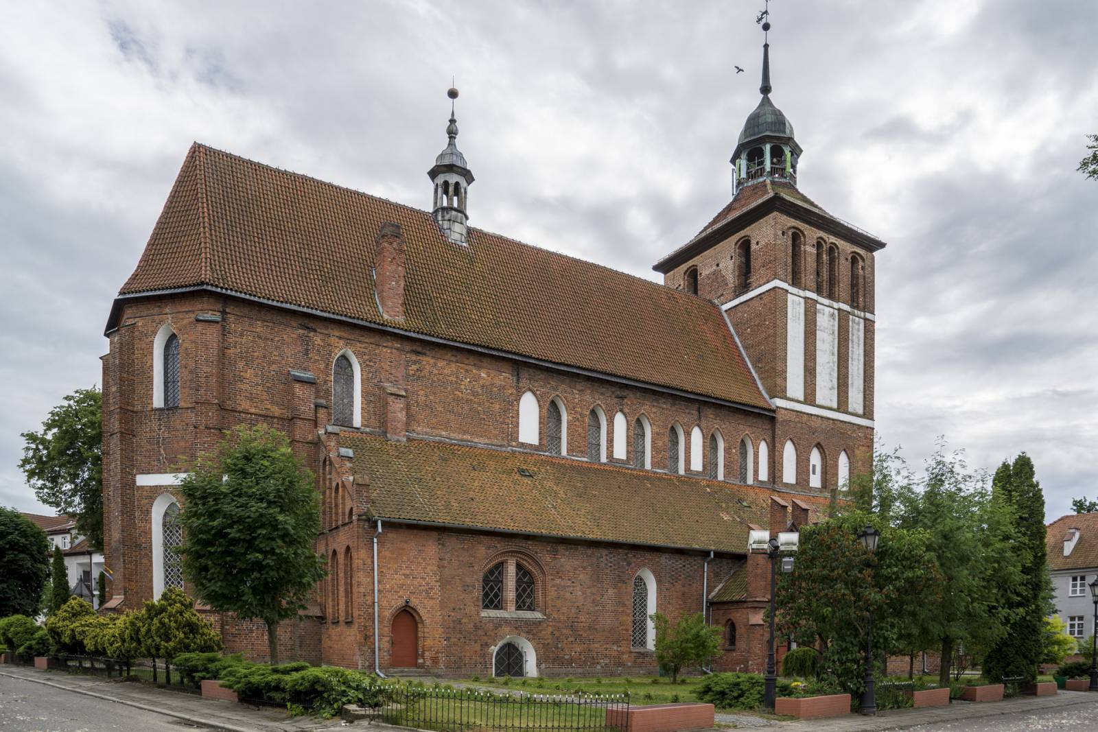
The trip throughout the borderlands of the Sępopol Plain starts in Bartoszyce. The first section of the trail leads through Skitno and Judyty to Szczurkowo. In 1945, the village was divided by the state border. Its part on the Russian side included the church and the palace, which have not survived until today. In the outskirts of the village, there is a milestone dating back to the 1st half of the 19th century, which contains information about the distance to Königsberg. The land is also one of the places where storks’ nests occur most frequently. The next important place on the trail is Stare Bardo. The village is largely inhabited by people of Ukrainian descent, who were resettled here after World War II. It is worth noting a 16th-century late Gothic church, which is currently a Greek Catholic church.
In Stopki – a village situated on the Łyna – you can rest by the river, which forms a large marsh at this point as a result of an eddy caused by the dam of the biggest water power plant built in Friedland (today Pravdinsk) in the 1920s. The trail leads farther to Sępopol. Because of its peculiar location in the bend of the Łyna, at the point where it is joined by the Guber river, the town is almost entirely surrounded by water. In front of the point where the Guber connects with the Łyna, there is a dam, a small water power plant, and a closed mill. It is worth visiting the 14th-century church of St. Michael the Archangel, inside which elements of furnishing from various epochs have survived. On the church tower, there is a viewing terrace and a museum exhibition. Another interesting object is an almost 30 metres tall historic water tower and a fragment of defence walls with the town crest. In the nearby Liski village, there is a Trakehner horse stud with a few hundred years of tradition. The remaining historic houses and farm buildings along with the administrator’s manor house form a unique manor complex. From Liski the trail leads back to Bartoszyce. It is worth seeing the historic centre of the town: the market square, a fragment of defence walls with the Lidzbark Gate and two Gothic churches.
Trail option (32 km):
A shorter option of the trail leads from Bartoszyce to Sępopol via Liski.
Surface and marking of the trail:
PARTLY MARKED TRAIL
The trail runs on asphalt roads of low traffic intensity; it partially overlaps with the Green Velo trail.
Attractions on the trail:
- Market square in Bartoszyce
- Lidzbark Gate in Bartoszyce
- Church of John the Baptist in Bartoszyce
- Church of John the Evangelist in Bartoszyce
- Greek Catholic Church of the Birth of the Blessed Virgin Mary in Ostre Bardo
- Fragment of defence walls in Sępopol
- Church of St. Michael the Archangel in Sępopol
- Water tower in Sępopol
- Horse stud in Liski
Course of the trail:
- 0 km – Bartoszyce
- 0 km – Skitno
- 0 km – Judyty
- 4 km – Szczurkowo
- 2 km – Ostre Bardo
- 24 km – Stopki
- 8 km – Sępopol
- 9 km – Liski
- 49 km – Bartoszyce
Tourist Information Point in Bartoszyce
- Bohaterów Warszawy 96, 11-200 Bartoszyce, phone 89 76 29 880
pit@bartoszyce.pl, www.gci.bartoszyce.pl