
 Highest point
 Lowest point
 Sum of driveways
 Sum of downhill
 Connected with GreenVelo
 Slope
Slope Marking
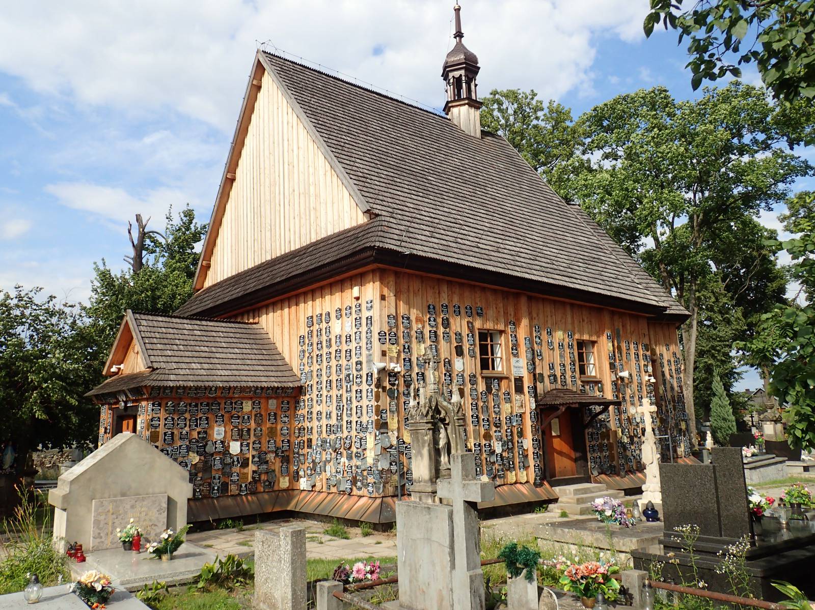
The green bike trail of the Stalowa Wola district is a quite long route, 86 kilometres long. It starts in the city of Stalowa Wola and runs along the San River valley and through the Janów Forests into the Vistula River valley, ending near the city of Sandomierz. The trail is poorly signposted, runs on a wide variety of pavements. The route is quite monotonous, but without hills and difficult sections.
The general course of the trail is as follows: Stalowa Wola, bridge on the San River (0.0 km) - Pysznica (3.0 km) - Kłyżów (7.9 km) - Szwedy (21.0 km) - Zaklików (49.2 km) - Chwałowice (75.2 km) - Wrzawy (86.4 km).
The trail is a half of a loop of around 160-170 km, running around Stalowa Wola County. The second part of the loop (signposted in blue) is 76 kilometres long and runs from the villages of Wrzawy through Zbydniów and Stalowa Wola to Nisko. Return to the starting point (to Stalowa Wola) is possible via national road no. 77 or through Zarzecze and Pysznica or the Green Velo trail through the localities of Skowierzyn, Radomyśl and Wola Rzeczycka. Such a bike trip, together with sightseeing, will take two days of cycling.
According to the map the route starts on the bridge on the San River in the city of Stalowa Wola. It is the third largest city in the Podkarpackie Province. It was established as a green field project, as part of the Central Industrial District built since 1937. The city has a modernist utility architecture, and in its northern part, in the former village of Rozwadów, the Baroque 18th century Capuchins cloister complex has survived. In the centre of the city there is a wooden church dating back to 1803 and a monumental basilica dedicated to the Virgin Mary, the Queen of Poland. On one of the city squares a huge hussar monument, called the Patriot Memorial, was erected.
The trail runs to the village of Pysznica. The name of the village, according to a legend, comes from the "delicious" water, which King Zygmunt August tried during his hunting expedition in the nearby Solska Forest. In the centre of the village there is a contemporary, neo-Baroque Exaltation of the Holy Cross and Saint John the Baptist Church. From Pysznica the trail runs along the San River, along the Green Velo route, to the locality of Kłyżów. At this section, however, there is no signposting.
Between the localities Kłyżów and Zaklików, at the section of nearly 40 kilometres, the trail runs through the vast, marshy Janów Forests complex. The first part of the route, to the village of Szwedy, is paved with asphalt. Further down, a section with a predominance of forest dirt roads begins. It is only in the little town of Zaklików that asphalt pavement reappears. In the little town of Zaklików, there is the old wooden St. Anna church, currently a cemetery chapel. On its walls, plaques with the names of the dead inhabitants of the village are attached. The Jewish cemetery is located next to it.
From here the route turns westwards to climb the edge of the Lublin Upland and again bring the cyclist to the plain. After a few kilometres, the Janów Forests end and the trail’s last section runs through the villages located in the vast valley where the Vistula and San Rivers meet. There are many floodplains and oxbow lakes in this area. At the final stage of the route, the hills on which Sandomierz is located are clearly visible. At the end of the trail, there is a ferry crossing through the San River. Further down, the trip can be continued along the blue route to the cities Sandomierz or Stalowa Wola, or you can return to the starting point of the Green Velo route through the locality of Radomyśl.
Points of interest along the trail:
- Stalowa Wola - museum, urban layout of the modernist town, wooden church
- The San River Valley
- Pysznica - a neo-Gothic church
- Zaklików: wooden church, the Jewish cemetery, "castle"
- The Janów Forests
- The Vistula Valley - oxbow lake
The entire trail is suitable for bicycles with panniers/bike trailers. The trail runs only on roads without road traffic or on local roads with a low and very low volume of road traffic; no dangerous intersections. A recreational trail.
Starting point:
According to the map, just after the bridge on the San River, in the city of Stalowa Wola. First signposting in the locality of Kłyżów.
Finishing point:
According to the map, at the river crossing in the village of Wrzawy, in the area before the river crossing in the village of Czekaj Pniowski.