
 Approximate driving time with sightseeing
 Highest point
 Lowest point
 Connected with GreenVelo
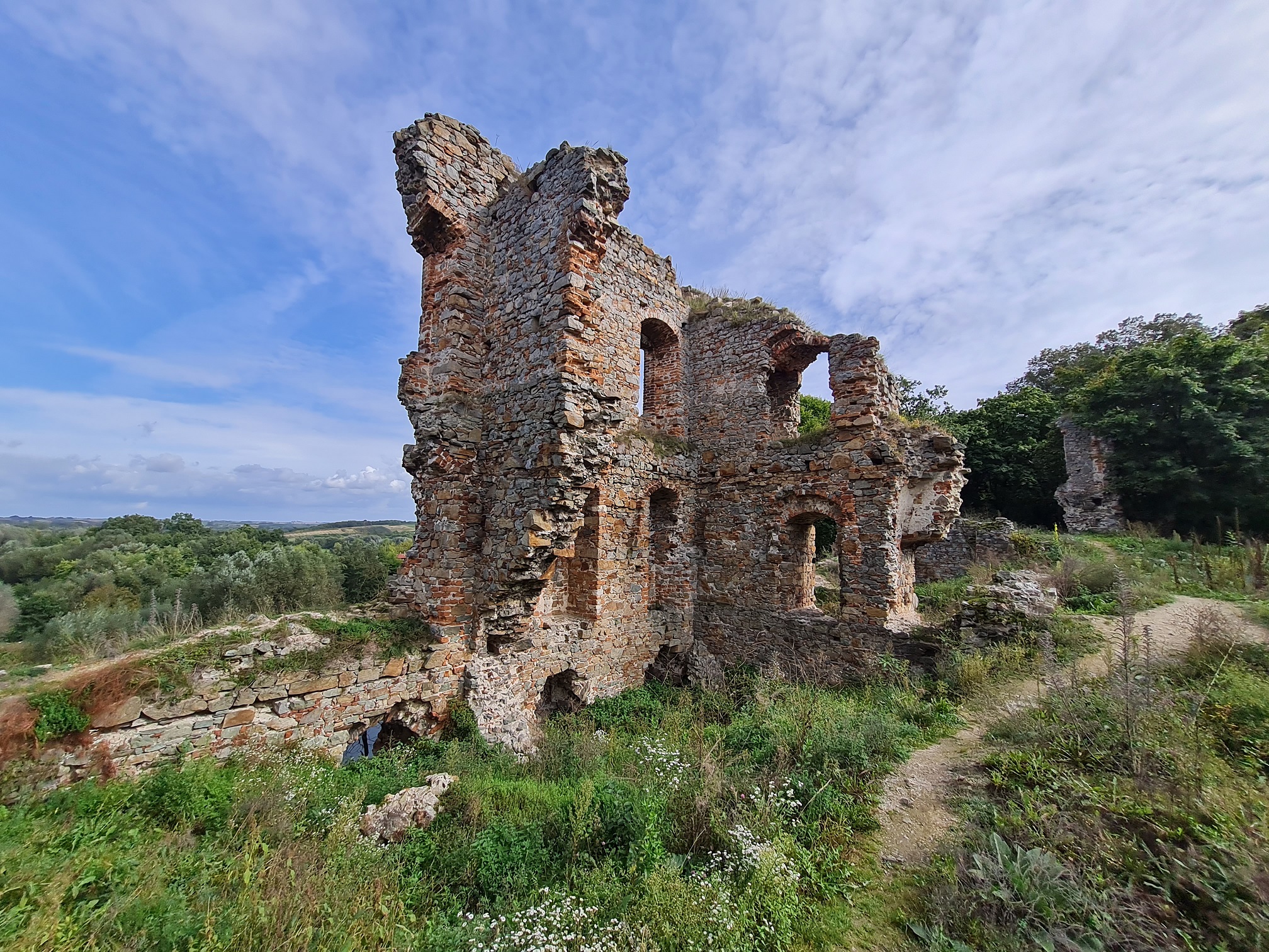
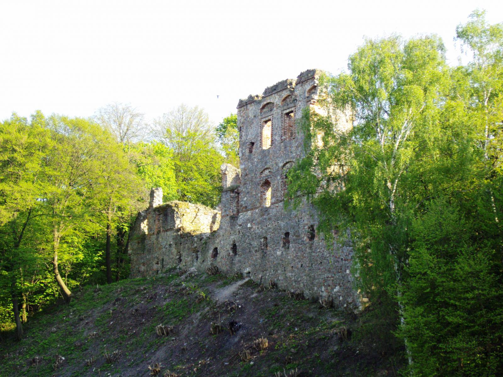
The trip can be a one-day trail ending in Opatów or a fragment of a longer expedition that, for example, lasts two days. Attention! Because the St. James Małopolska Trail is marked only on one side, we do not recommend reversing the trail and starting in Opatów. The trip starts in the parking area at the Opatów gate. From there, without a trail, turn left into ul. Browarna; then, riding on ul. Mickiewicza, reach the intersection with ul. Koseły. Here turn left again to find the marks of the yellow cycling trail that crosses with the St. James’s Trail. Turn right into ul. Rokitek. From now on, you will follow the marks presenting a gold seashell. You will pass the legendary Salwe Regina hill in the Sandomierz region. It will not be the last mysterious place on our trail. After riding around 6 km, you will see the Kwacała’s Mound standing among beautiful orchards – according to the tradition, it is connected to Mongol invasions of the Sandomierz Land. Archaeological research showed that these areas had already been inhabited in the Neolithic period. Past the church in Świątniki, the St. James’s trail turns left, and you turn right. Farther, without any marks, turn left in Piekary to arrive through Święcice to Kleczanów, where a 17th-century church charms visitors with the simplicity of wooden architecture. Here you will also come across the marks of the green hiking trail and, after crossing the road no. 9, the trail of fortified architecture, along which you will ride to Międzygórz. Here, among green trees and shrubs, imposing ruins of a medieval stronghold have survived. From the ruins, a picturesque view of one of the tributaries of the Opatówka stretches out. In the small village of Tudorów, where you will arrive along the marks of the green and black cycling trail, on the hill surrounded by the meanders of the Opatówka from three sides, the quadrangular tower of a 14th-century knight’s castle has survived. According to one legend, the castle was founded by Jan Tudor, whose descendants sat on the English throne. However, documents attribute the act of foundation to the knight Pełka. From Tudorów, after crossing the road no. 9 again, you will ride to Opatów – a city with 700 years of history, where it is worth staying for longer to visit the Roman collegiate church, the market square and the underground tourist trail.
Course of the trail:
- Sandomierz – 0 km
- Kobierniki – 3 km
- Kwacała Mound – 5 km
- Śmiechowice – 5 km
- Świątniki – 5 km
- Święcice – 21 km
- Kleczanów – 5 km
- Międzygórz – 28 km
- Żurawniki – 5 km
- Tudorów – 38 km
- Okalina – 41 km
- Opatów (Market Square) – 44 km
Trip options:
The trip can be a one-day trail ending in Opatów or a fragment of a longer excursion that, for example, lasts two days. Attention! Because the St. James Małopolska Trail is marked only on one side, we do not recommend reversing the trail and starting in Opatów.
Marking and infrastructure:
- The first kilometre of the trail (ul. Browarna and Adama Mickiewicza in Sandomierz) does not run along any trail. At the intersection of ul. Mickiewicza and ul. Romana Koseły, you will see the marks of the yellow cycling trail marked according to the marking instruction for PTTK tourist cycling trails (in the top part of the mark, the symbol of a bike in black is placed, and the bottom part contains a yellow rectangle).
- After around 700 metres, you will come across the marks of the St. James’s Małopolska Trail: the unconventional one-sided marking presents the symbol of a gold seashell against a blue background.
- The Świątniki – Bilcza – Piekary – Święcica – Kleczanów section is not marked.
- From Kleczanów to Opatów, you will ride along visible black marks of the Świętokrzyski Trail of Fortified Architecture (the standard marks contain also the outline of a fortified building).
- In addition, the green cycling trail runs parallel to the Trail of Fortified Architecture from the surroundings of Międzygórz to Opatów.
Infrastructure:
- Bike stands at the building of the Opatów City and Commune Office.
- It is possible to find accommodation in Sandomierz and in Opatów.
Surface:
- 9% of the trail runs on an asphalt surface.
- When leaving Sandomierz, you will come across a short section with an openwork plate surface (around 360 m) and a ground surface (around 250 m).
- A longer section of the unsurfaced road (around 3 km) followed by a gravel road (around 350 m) starts after 8 km of the trail (after the passage across the road to Obrazów).
- The next sections of the gravel road (around 820 and 930 metres in length) occur respectively at the end of the 13th kilometre and at the beginning of the 25th kilometre of the trail.
- The last section with the ground surface (around 2 km in length) is located in front of the entrance to Opatów.
List of attractions on the trail:
- Old Town in Sandomierz (Tourist Information Centre, ul. Rynek 20, 27-600 Sandomierz, phone 15 644 61 05, informacja@sandomierz.travel, sandomierz.travel)
- Kwacała’s Mound
- Church of Catherine and St. Stanislaus in Kleczanów (Kleczanów 111, 27-641 Obrazów, phone 15 836 61 05)
- Ruins of the castle in Międzygórz
- Ruins of the castle in Tudorów
- Opatów (Tourist Information Centre, pl. Obrońców Pokoju 34, 27-500 Opatów, phone 15 868 13 01, e-mail: informacja@opatow.travel, opatow.travel)
- Underground Tourist Trail in Opatów (pl. Obrońców Pokoju 18, 27-500, phone 15 868 27 78)
- Collegiate Church of Martin in Opatów, ul. S. “Grota” Roweckiego 8, 27-500 Opatów, phone 15 868 27 64